
Hundreds of Roman Empire fortresses have appeared in old spy satellite images taken over Syria, Iraq and nearby territories in the eastern Mediterranean. These satellites were once used for reconnaissance in the 1960s and 1970s, but their data is now declassified. Some of their archived images allow new archaeological studies in areas of the Earth that are often difficult for researchers to visit, either for military reasons or because of the difficulties of the terrain.
The 396 forts found, seen directly from space, confirm and extend an aerial survey of the region carried out in 1934. This survey had recorded 116 forts on the eastern border of the Roman Empire. This may be further evidence to support the idea of some archaeologists regarding the hypothesis that Rome was strengthening its border to the east.
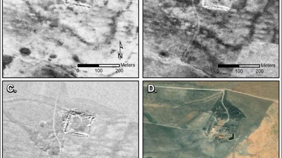
Jesse Casana, professor of Middle Eastern anthropology at Dartmouth College in New Hampshire, in his study published in "Antiquity", leaves open a hypothesis and explains: "These forts are similar in form to the Roman ones present in other parts of Europe and North Africa. There are more castles in our study than elsewhere, but this may be because they are better preserved and easier to recognize. However, it may also be the result of intensive fort building, especially during the 2nd and 3rd centuries AD".
In a 1934 survey based on aerial flights carried out in the 1920s, the French archaeological pioneer Antoine Poidebard found 116 forts and suggested that the fortifications must have been a line of defense against the Persians. But one limitation of his work was that he flew his aircraft mostly where he believed they would find forts. The new satellite imagery study by Casana and other researchers was able to cover more ground and overcome the biases of Poidebard's study.
Thus Casana showed that the 396 newly discovered forts had no obvious defensive pattern against the eastern peoples, but were scattered almost everywhere. The new results may confirm the hypothesis of some previous researchers, that Poidebard's 116 forts were too far away to form a line of defense. However, camps in present-day Syria and Iraq were used to protect caravans carrying valuable goods to and from Rome's provinces while allowing for cross-cultural communication and exchange.
The images in the study come from two satellite programs originally used for surveillance during the Cold War between the United States and the Soviet Union and their respective allies. One of the objectives of the Cold War was rapid military reconnaissance via satellites capable of instantly bringing photographic images back to Earth. The Corona program of the Central Intelligence Agency (CIA), with the help of the US Air Force, retook areas of nations such as China and the Soviet Union between 1959 and 1972. A later program called Hexagon (also called Big Bird, KH-9 or KeyHole-9) continued the study of Soviet military sites between 1971 and 1986, led by the National Bureau of Reconnaissance. The most important element was that these satellites were specially built to obtain clear and accurate images. And the declassification of images has provided archaeologists with rich ground for data collection and analysis, since images are easy to find.
(A2 Televizion)
A2 CNN Livestream
MUND TE LEXONI GJITHASHTU


